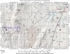
- Location
- Sandy, Ut
Cat Canyon Trailhead
West Desert Area (approx. 120 miles Southwest of SLC)
Cat Canyon
N 39-04'59.9"
W 113-34'23.9"
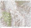
West Desert Area (approx. 120 miles Southwest of SLC)
Cat Canyon
N 39-04'59.9"
W 113-34'23.9"
Originally posted by mbryson
How's Cat Canyon.....isn't that like a 5+ on the Moab scale? (Pritchett being a 5 because of Rocker Knocker and Rockpile?)
Originally posted by Shawn
4+
Originally posted by Shawn
I didn't think it was all that hard.
But, Hell's isn't either,,,
Originally posted by mbryson
Can't disagree with that.....My XJ would be OK then, huh? (I always enjoy trail rides more when I'm HELPING someone else that broke!!!!)
 .... Just make sure you bring extra ball joints.... I have always wanted to seek revenge on that trail...
Originally posted by cruiseroutfit
Your XJ.....I dunno....
As far as how hard Cat Canyon is... I broke a pitman arm in the middle so??? I will go do it with ya'
), and I'll carry a whole set of spare ball joints and the tool to remove them {so then maybe I won't need them }Originally posted by mbryson
So is there cool places to camp or is it kind of a one day trip?
Originally posted by mbryson
) for some TJ axles with the 297 joints (they're basicly the same that I have, minus the cool ABS tone ring
is this trail still open?