- Location
- Grand Junction, CO
Sego, Utah is a town with a very interesting and difficult history. It was established as company town with its roots in mining, beginning in the 1890's. Sego is located in Grand County, North of Thompson by about 5 miles. The town of Sego had changed names a few times, usually being named after the current land owner or the manager of the mine. Eventually the name of Sego stuck, named after the Utah state flower, the Sego Lily was abundant in the canyon.
The mining activity wasn't due to a gold or silver strike, but rather coal. A rancher by the name of Henry Ballard was in the hills above Thompson running his sheep and cattle when he stumbled upon a vein of coal on the surface of the ground. Ballard was quite the business man, owning most of the land and many of the buildings in Thompson. He quickly saw the potential with the coal to heat homes and began selling coal to the locals. Folks could buy coal at the store Ballard owned in Thompson or drive their wagon to the mine to haul the coal themselves. Customers were coming by wagon from as far as Monticello, UT nearly 100 miles away.
In 1911 the Ballard and Thompson coal company was incorporated and plans were made to build a railroad to haul coal from the mine down to the Denver & Rio Grande Western Railroad mainline in Thompson.
By the end of 1911 the mine had 125 employees and the town of Sego (called Nelson at that time, after the manager of the mine) had 500 people living in it. A company store was built along with a boarding house. Oddly enough the company allowed the miners to build their residences anywhere in the canyon they pleased, leading to many buildings scattered throughout the canyons.
At the end of 1912 the Ballard & Thompson Railroad was completed, running for 5 miles. The railroad operated on grades as steep as 4 degrees and ran on 65 pound rail, along with 3.3 miles of 45 to 57 pound rail, which was manufactured as early as 1888. (Rail is measured by it's weight in 3' lengths, the weight of a specific rail measured 3' long gives you it's size. Modern rail weighs any where from 133 to 141 pounds per 3' length.)
Soon the mine was moving 600 tons of coal per day, but it wasn't without trouble. The town's water table had been dropping quickly from the very beginning and the water supply had slowed to a trickle at times. In contrast to the water table running dry, there were frequent flash-floods running down the canyon, washing out many of the railroad bridges and trestles. It's reported that the train had ran off the track or wasn't able to operate as much as 1/4th of the time. Much of the coal was being taken to Grand Junction, CO purchased by the D&RGW railroad for their steam engines.
By 1915 profits were so low that many miners had not seen a paycheck for several months. The miners were instead paid with script, which allowed them to purchase food & supplies at the company store.
At this point the mining management & ownership changed hands in an effort to increase profits. This happened a few more times in the mines troubled history, until the mine, now owned by the Chesterfield Coal Company, had it's property sold off by a Sheriffs sale located in Moab during 1947. The miners went in together and purchased the mine in order continue making a living in the area. After 2 disastrous fires at the mine, the D&RGW railroad told the coal company that there was not enough traffic to justify the costs of maintaining the rail line and that they were going to pull up the tracks.
Even with the railroad gone, the mine struggled to operate using a loading ramp and a truck to haul coal. Shortly after the railroad pulled out, the demand for coal by the railroad changed as they movedfrom steam-driven engines to diesel-electric locomotives. This sealed the fate for the mine and it was shut down.
In 1955 the property was again sold, but not for it's coal. This time a company from Texas purchased the property to pursue the underground oil and natural gas.
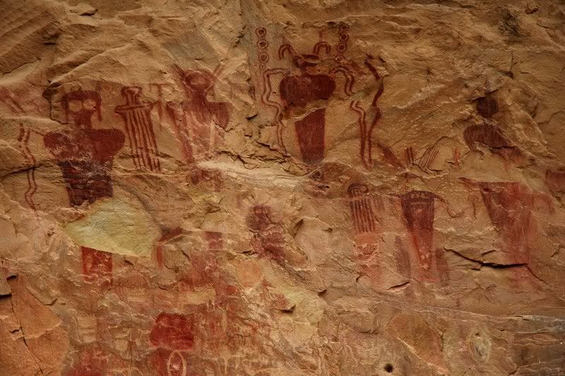
Long before any white men ranched in this area, ran cattle or mined coal, another group of people called this place home. And like the miners, they also left their mark on the land. At the bottom of the canyon are several panels of Pictographs from different ages. The painting styles range from as long ago as 7000 BC by the Barrier people to as recently 1600 AD by the Utes, with the Fremont people living here in between.
Saturday Feb 21st, 2009
Catherine and I decided to take the drive to Sego and explore the ghost town and study the great Pictographs and Petroglyphs. It was a perfect day for a trip into the canyon, temperatures were mid-50's and we had the place to our own, for the most part.
The first place we came to were the panels of pictographs.-


The mining activity wasn't due to a gold or silver strike, but rather coal. A rancher by the name of Henry Ballard was in the hills above Thompson running his sheep and cattle when he stumbled upon a vein of coal on the surface of the ground. Ballard was quite the business man, owning most of the land and many of the buildings in Thompson. He quickly saw the potential with the coal to heat homes and began selling coal to the locals. Folks could buy coal at the store Ballard owned in Thompson or drive their wagon to the mine to haul the coal themselves. Customers were coming by wagon from as far as Monticello, UT nearly 100 miles away.
In 1911 the Ballard and Thompson coal company was incorporated and plans were made to build a railroad to haul coal from the mine down to the Denver & Rio Grande Western Railroad mainline in Thompson.
By the end of 1911 the mine had 125 employees and the town of Sego (called Nelson at that time, after the manager of the mine) had 500 people living in it. A company store was built along with a boarding house. Oddly enough the company allowed the miners to build their residences anywhere in the canyon they pleased, leading to many buildings scattered throughout the canyons.
At the end of 1912 the Ballard & Thompson Railroad was completed, running for 5 miles. The railroad operated on grades as steep as 4 degrees and ran on 65 pound rail, along with 3.3 miles of 45 to 57 pound rail, which was manufactured as early as 1888. (Rail is measured by it's weight in 3' lengths, the weight of a specific rail measured 3' long gives you it's size. Modern rail weighs any where from 133 to 141 pounds per 3' length.)
Soon the mine was moving 600 tons of coal per day, but it wasn't without trouble. The town's water table had been dropping quickly from the very beginning and the water supply had slowed to a trickle at times. In contrast to the water table running dry, there were frequent flash-floods running down the canyon, washing out many of the railroad bridges and trestles. It's reported that the train had ran off the track or wasn't able to operate as much as 1/4th of the time. Much of the coal was being taken to Grand Junction, CO purchased by the D&RGW railroad for their steam engines.
By 1915 profits were so low that many miners had not seen a paycheck for several months. The miners were instead paid with script, which allowed them to purchase food & supplies at the company store.
At this point the mining management & ownership changed hands in an effort to increase profits. This happened a few more times in the mines troubled history, until the mine, now owned by the Chesterfield Coal Company, had it's property sold off by a Sheriffs sale located in Moab during 1947. The miners went in together and purchased the mine in order continue making a living in the area. After 2 disastrous fires at the mine, the D&RGW railroad told the coal company that there was not enough traffic to justify the costs of maintaining the rail line and that they were going to pull up the tracks.
Even with the railroad gone, the mine struggled to operate using a loading ramp and a truck to haul coal. Shortly after the railroad pulled out, the demand for coal by the railroad changed as they movedfrom steam-driven engines to diesel-electric locomotives. This sealed the fate for the mine and it was shut down.
In 1955 the property was again sold, but not for it's coal. This time a company from Texas purchased the property to pursue the underground oil and natural gas.
Long before any white men ranched in this area, ran cattle or mined coal, another group of people called this place home. And like the miners, they also left their mark on the land. At the bottom of the canyon are several panels of Pictographs from different ages. The painting styles range from as long ago as 7000 BC by the Barrier people to as recently 1600 AD by the Utes, with the Fremont people living here in between.
Saturday Feb 21st, 2009
Catherine and I decided to take the drive to Sego and explore the ghost town and study the great Pictographs and Petroglyphs. It was a perfect day for a trip into the canyon, temperatures were mid-50's and we had the place to our own, for the most part.
The first place we came to were the panels of pictographs.-


")