
I guess I'm interested in knowing how you use navigation when you're on trips Dave. Do you build a route before heading out and follow that or do you show up in an area and use the nav to see if X road will get you through to Y location. Maybe a combination of the two? What specifically was your Garmin able to do that isn't a feature now?
You are using an out of date browser. It may not display this or other websites correctly.
You should upgrade or use an alternative browser.
You should upgrade or use an alternative browser.
Tablet mount in TJ?
- Thread starter DAA
- Start date
DAA
Well-Known Member
- Location
- West Bountiful, UT
I guess I'm interested in knowing how you use navigation when you're on trips Dave. Do you build a route before heading out and follow that or do you show up in an area and use the nav to see if X road will get you through to Y location. Maybe a combination of the two? What specifically was your Garmin able to do that isn't a feature now?
Boy, that could take a while to answer!
Just briefly, and maybe I'll try and get into more detail later, but here are a couple very short answers to your questions.
No, I don't build routes. Have never built a route. Don't know how. Don't know what use a route would be to me. I like to stay fluid and make route choices on the fly most of the time.
Yes, I use the nav to see where X road goes, constantly. I'm accustomed to doing it on a dedicated GPS, with hardware buttons though. Meaning, I'm accustomed to doing it while bouncing down a rough two track, with one hand, mostly by braille and being able to accomplish the whole operation in about two seconds with only one second to actually look at the screen and get the info I want. I envision I'll have to come to a stop and focus my attention on the tablet to do the same thing using touch screen and raster maps. Which, will crimp my style! I've been on a couple trips with guys using these systems and it seems like they always have to stop and waste time just to make nav decisions that I'm accustomed to doing without slowing down or scarcely even taking my eyes off the trail.
A couple quick complaints about raster maps, which, aside from having dedicated hardware buttons (touch screen just sucks, by comparison, for vehicle nav, in my opinion...), vector maps is what I miss most about my Garmin compared to these Android tablet apps.
1. Raster maps are freaking huge and take forever to download. Vector maps are a tiny faction of the size, load dozens to hundreds of times faster (depending on the particulars) and take up only a tiny fraction of the disk space. As a simple example, I just downloaded CoPilot, a street nav program - won't be useful at all for offroad nav, but emulates typical street GPS function. Anyway... It uses vector maps and complete street maps of the USA and Canada are only about 2.6 GB. By comparison, I've been downloading several sets of topo maps for a trip to The Maze I'm leaving on later today. So far, a couple sets of raster topos for just The Maze are sitting at about 3 GB. Probably end up with about 7GB worth for just this one small area, since I want to try out some different types. I can imagine that just Utah, for the 24K topos, in raster format, must be dozens of GB.
2. Raster maps don't scale smartly. Here is an example of what I mean. The CalTopo 24K are a popular free map for BCN or Gaia. And they are great for hiking. But, they just plain suck for my purposes in vehicle nav. The road on them is just a pair of dashed lines, against varying backgrounds. Zoom in tight enough and it works fine - you can plainly see the terrain features and road path for a short distance around. But, if you want to do a quick reconnaissance of where a side road goes, so you zoom out, pretty soon, you can't see the road anymore. Those little dashed lines just keep getting smaller as you zoom out until they very quickly aren't distinguishable at all anymore. Ditto for text labels on the map.
Vector maps scale smartly. As you zoom out, the road (dirt two track, highway, whatever), doesn't get so small you can't see it. Roads (and certain other features) have a minimum pixel dimension they shrink to which is still very visible. So, as you zoom out to view a wider area, you can easily see the roads around you and where they go. In similar vein, roads are typically color coded - on my old Garmin, during daytime (it had very useful separate color schemes for day and night), dirt roads are green and paved roads are red, on a tan background. Good contrast, very easy to see all roads of all types at all times. With dedicated hardware zoom buttons, it was a two second deal, even while bouncing on rough road, to "beep" the zoom out button a few times, glance at the screen and see that yes, that green dirt side road goes through to the red highway. Information acquired. Beep the zoom in button a few times, back to the preferred zoom for driving. All in about two seconds, and all of the actual zooming done by braille without even taking my eyes off the road. Contrast that to BCN or Gaia using the CalTopo 24K's. To accomplish the same thing, I'm going to have to come to a stop first. No way I can navigate those little touch screen zoom buttons effectively while bouncing on a rough track. Then, I'm going to be limited in how far I can zoom out before map features become indistinguishable, which means I'm also going to have to pan the map - more reason I need to stop to do it. A big deal? No, not really. But, repeating this a dozen times in a day, vs. just maintaining forward progress the whole time, is a minor PITA, to be sure.
Note, BCN has a set of free raster topos that emulates scaling in a way. It's not perfect, but it's better than anything comparable I've seen in Gaia so far. They have a set of ArcGIS topos that actually download three separate sets of maps - 250K, 100K and 24K and smartly switch map layers as you zoom in or out. These "may" end up being my go to, for BCN, we'll see. They take up a TON of space though!
3. Raster maps are basically just "dumb" images. So, there are many "features" where this comes into play, but I'll just list one that is most obvious and bothers me all the time. Again using the CalTopo 24K's as an example. "Track up" is the ONLY way to fly, for vehicle nav. But, running track up with a dumb raster map, if you are going south, all the text labels on the map are upside down and backwards! Nice... Not...
There are many, many other ways the "dumb" nature of raster maps prevent features you take for granted using a GPS that uses vector maps.
Note, it's obvious that both BCN and Gaia were designed for hiking. And for use typically on a smaller phone screen. Not in vehicle, off-road nav, using a typically larger tablet screen. Aside from the raster vs. vector maps thing, I'm seeing a LOT of simple UI elements that could be changed to make these programs far easier to use, for how I personally will be using them. A simple example - the zoom in/out buttons in Gaia. They are tiny and close together. I'm sure some people master them while moving. But I just can't see my fumble fingers ever being able to use those zoom buttons worth a darn while bouncing down a rough track. By simply providing a UI option to make the buttons much larger and on opposite sides of the screen, functionality for my purposes would be significantly enhanced. I see LOTS of small things like this I wish were different.
Adding a UI style for "Offroad Vehicle" and another one for "large screen" could increase usability greatly for my purposes.
Having worked for a software development company for 25 years and actually having designed some successful (or at least profit making) programs in the long ago time, I know that good software companies typically crave this kind of feedback from users and are anxious to try and implement many requests and suggestions. As such, after I become a bit more familiar with the programs, you can bet I'll be lighting up the customer feedback inboxes at both companies.
- DAA
DAA
Well-Known Member
- Location
- West Bountiful, UT
BTW... I don't want to get too far ahead of myself on BCN vs. Gaia, not until I have actually used them some. But I do see things I like more about one or the other.
One of the things I liked better about Gaia before, that still appears true, is that it is much more stable than BCN. Have had BCN just stop running twice this morning, trying to get some maps downloaded. And I have now purchased the AccuTerra maps, but can't get them to display, let alone download. I go to the more map sources list and it shows them as already purchased. I do to display them and it says I need to purchase them... Arrrghh...
Anyway, just seems from my limited use so far and previous use, Gaia is more stable and BCN is a lot more buggy...
- DAA
4wheelair.com
New Member
And I have now purchased the AccuTerra maps, but can't get them to display, let alone download. I go to the more map sources list and it shows them as already purchased. I do to display them and it says I need to purchase them... Arrrghh...
- DAA
I believe I may have had the same issue initially. I think it had something to do with where the maps were downloaded (sd card vs internal memory). BCN was pointed to the wrong location.
DAA
Well-Known Member
- Location
- West Bountiful, UT
Okay... I'll try and stop the running commentary  .
.
Just a quick note to say - I got the AccuTerra maps working, downloading now. They do work better for seeing dirt roads - the solid white lines contrast much better and are much easier to see on the screen than those dashed lines on the free 24K's. And the roads are color coded too, which is definitely helpful.
Space requirements aren't as bad as some of the other options too. Downloading 660MB for my Maze trip. Still pretty freaking huge files, but...
I see why you guys use them compared to the free topos. They are an improvement for sure.
- DAA
.Just a quick note to say - I got the AccuTerra maps working, downloading now. They do work better for seeing dirt roads - the solid white lines contrast much better and are much easier to see on the screen than those dashed lines on the free 24K's. And the roads are color coded too, which is definitely helpful.
Space requirements aren't as bad as some of the other options too. Downloading 660MB for my Maze trip. Still pretty freaking huge files, but...
I see why you guys use them compared to the free topos. They are an improvement for sure.
- DAA
Thanks for that explanation Dave. I figured that you didn't build routes but didn't know how to phrase the question better. I've never used BCN and my tablet like you do so at first I just didn't understand why you were having the issues that you were. I totally understand now though and it makes sense that you would want the features that you do. I've noticed the same thing on zooming in and out and having the roads disappear but didn't know why that was happening. It wasn't a big deal for me because of how I was using it but still.
I guess I'm even more intrigued now that I've read how you use GPS and look forward to reading more about what you figure out and how it all works for you. I hope you can have a good trip and don't have to fumble with this new tech and miss enjoying the trip.
I guess one plus of the Samsung tab is that its got the micro SD slot, not that you'd want to rely on it but as I'm sure you know, you can get some pretty quick cards for expanded memory.
Thanks again.
DAA
Well-Known Member
- Location
- West Bountiful, UT
No worries on this trip. I could do The Maze blindfolded, almost. Really won't have any need for GPS or nav. But, it's a good opportunity to test the apps and maps out and see what I can see.
I already had a class 10 128GB card, so that's where I'm putting all the map data. Good thing, too. Looks like I'll end up having downloaded about 7GB worth! If I settle on a single map type - AccuTerra for instance, I won't need nearly that much space for one area like The Maze, but, still I'll want all of Utah and Nevada stored for offline use and that would eat up all the internal memory (which is 32GB on this tablet) real fast!
- DAA
DAA
Well-Known Member
- Location
- West Bountiful, UT
Okay, just a few notes, comments, observations as I learn these apps... I know I'm being longwinded and not many people will have ANY interest in this. But if I had found these notes, made by someone else, it could have shortened my learning curve and saved me a lot of time and I'd have been grateful. So, I'll keep posting them in the hopes they'll help someone else later.
Have just found out a couple things about how BCN works, that suck. One of the things that sucks about BCN, by the way, is the documentation. There isn't much of it and it isn't very good. Gaia has much better documentation - much!
Anyway, sucky things I'm learning about BCN... There does not appear to be any option for "track up"? I can live with this. Unhappily. But can live with it. I guess.
Much worse, is how BCN handles the display, saving and exporting of tracks and waypoints. I realize, this is just me and how I like to use my GPS, might not apply or matter at all to anyone else. This is huge for me though - dang near just a disqualification for BCN, for me - I'm not sure I can live with it at all. Quick summary...
BCN stores waypoints and tracks in "trip database" files. You can create and name these files, and import tracks and waypoints to them. You can also export the tracks and waypoints from them. That's all good. But here's where it gets real, real crappy... BCN only displays the tracks and waypoints from one trip database file at a time. When you save a new track or waypoint it saves to the current trip database. When you go to export, it exports THEM ALL, with no options for selecting which tracks and waypoints get exported.
What this means, is that to see all my existing waypoints, I have to have them in the current trip database. But if I create new waypoints, they also go in that database. At the end of the trip when I want to export the new waypoints from my trip, there is no way to separate them from the 2,800 other waypoints in the database. All you can do is export them all. To export only the new waypoints, I have to put them in a new database file when I create them. But then BCN won't display any of my other 2,800 waypoints, only the few new ones in the new database. There is no way to display all existing waypoints, and new ones, and then be able to export only the new ones. For how I actually use a GPS and waypoints, this sucks massively. Just about unusable. Kludge and PITA and overly complicated and time consuming and not effective, at best.
Heavy sigh...
Gaia lets you do track up. I haven't tried creating new waypoints or exporting them with it yet though. I like the AccuTerra maps in BCN better than the Gaia maps, and some other features of BCN I like better too. Waypoints are labeled on the map in BCN, not on Gaia, plus one for BCN there, for instance. But if Gaia will let me display all my waypoints, both old and new, at the same time, but then export only the new ones, I really won't have any choice as to which app works best for me.
What a sucky piece of software BCN is...
- DAA
Unimog
Eric
- Location
- Stansbury Park, UT
Dave, don't apologize for the details. It is your thread and I'm pretty sure a bunch of us will benefit from the analysis, even if we can't help you make it better.
- Location
- Vehicular limbo
What is "track up"?
I guess I don't understand the objection to how BCN handles waypoints? I've never wanted to separate previously planned points from ones I create, and if I did I can't see the huge hassle in doing it manually. But I guess we do GPS differently, I don't create new tracks or waypoints on the fly very often.
FWIW, all of your complaints are all of what I've hated about any of the GPS mobile apps I've tried, and that's that none of them hold a candle to what I can do from my desktop at home. I'm looking forward to having that capability on the fly, now I've just got to find a spare $100 for the software!
Unimog
Eric
- Location
- Stansbury Park, UT
Track up rotates the map so the top is where you are heading instead of north on top
Looking at Delorme's website they have a new mobile app out that allows you to use there maps without the inReach system, might want to check it out. I think I will be trying it, they have really nice maps and good features that others require subscriptions for
http://shop.delorme.com/OA_HTML/DELibeCCtdItemDetail.jsp?item=35408§ion=10900
http://shop.delorme.com/OA_HTML/DELibeCCtdItemDetail.jsp?item=35408§ion=10900
DAA
Well-Known Member
- Location
- West Bountiful, UT
Track up rotates the map so the top is where you are heading instead of north on top
Exactly.
Track up, is this what you're trying to adjust?
Settings=>compass and rotation options=>map/pointer rotation direction=>moving direction
And yup, that does it!
Looking at Delorme's website they have a new mobile app out that allows you to use there maps without the inReach system, might want to check it out. I think I will be trying it, they have really nice maps and good features that others require subscriptions for
http://shop.delorme.com/OA_HTML/DELibeCCtdItemDetail.jsp?item=35408§ion=10900
When I was looking at that on their site last week, it wasn't shipping yet and I had read about it somewhere else that it has been "coming soon" for a long time. And I've never been too impressed with Delorme's maps, but it looks interesting and I'll probably try it too. The "unique map format means you can download more data, faster" is kind of vague, but it has me interested enough to try it out!
My new tablet has been downloading a single set of AccuTerra maps for BCN for my next trip for over 3 hours now - a single download, of one map set, for one area. It's going to take weeks, literally, weeks of constant downloading all day every day, to download just the AccuTerra maps for my area of operations and I want to have more than just the AT maps stored. Major, major, M-A-J-O-R pain in the AZZ!
I'm digging the tablet, nice big display is nice. Multi use is nice. But so far, I'm really just not liking it for offroad nav anywhere even close to a dedicated GPS. There are a few things I do like better about using the tablet, but there are a whole lot more things that I just don't like at all about it.
I used BCN most of the time on the trip I just took. No real surprises, either good or bad. There is a lot I don't like about it, but it is totally serviceable, I can make it work for me.
Gaia, I only used for half a day. For the most part, I like it better than BCN. It's just easier to use, fewer, easier steps to do all the same stuff. But, it locked up and had to be closed twice in half a day, so I bailed on it. If it's going to keep doing that, it's just going to be disqualified for my use... I'll probably try it again on my next trip, but if it does that crap again, I'm done with it.
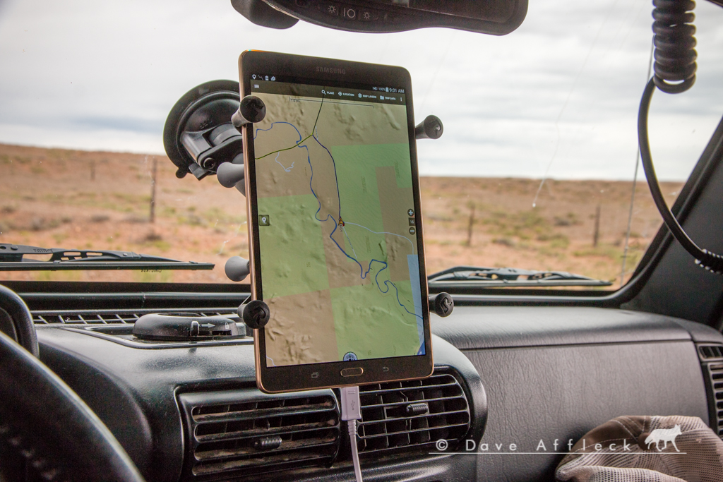
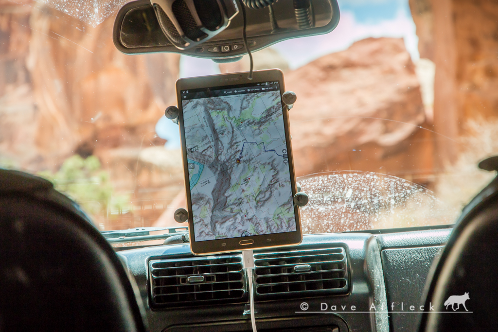
The reason I started this topic, was just for a mount solution. Nate suggested the Ram mount X-Grip and that is what I got to try this weekend. I put it on a Ram suction cup mount just for this weekend, with plans for a permanent base mount on the dash for later. I'm just not a fan of suction cup mounts. But, this one did not budge, at all, over 4 days and 250 miles of dirt. The X-Grip mount itself was rock solid too - it's a perfect solution, far as I'm concerned. I probably will still get a hard mount base for it, but all in all, I am totally pleased with this mounting solution!
- DAA
- Location
- Vehicular limbo
That's good to hear, I've been waiting for somebody to say the XGrip was all that. I'll get one, thanks!