any wheelin near granite flats camp in af???

camcruiser13

Active Member
going to a reunion this weekend at granite flats and wanna do some wheelin, is their anything other than the mineral basin near granite flats? i have only been up th roads going up the mineral basin side of things.

let me know.. thanks fellas
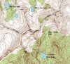
 

cruiseroutfit

Cruizah!
Moderator
Vendor
Location
Sandy, Ut
You can head up to Silver Flat Reservoir... there are two trail above it.

1. Eagle-Earl Mine Road aka Upper Major Evans Gulch, it winds up the mountain but eventually ends at a gate.

2. Milkmaid Trail, winds up the opposite side of the canyon to some old mine remains and a shorter hike to Silver Reservoir.

While neither are very technical, both offer some neat scenery, etc...
 

Meat_

Banned
Location
Lehi
You can head up to Silver Flat Reservoir... there are two trail above it.

1. Eagle-Earl Mine Road aka Upper Major Evans Gulch, it winds up the mountain but eventually ends at a gate.

2. Milkmaid Trail, winds up the opposite side of the canyon to some old mine remains and a shorter hike to Silver Reservoir....
So is this where I bust your balls over names?
 

camcruiser13

Active Member
hmm

i need that stinkin book of yours kurt!!!

well if theirs nothing technical i guess ill burn up mineral, i guess thats as good as it gets?
 

cruiseroutfit

Cruizah!
Moderator
Vendor
Location
Sandy, Ut
So is this where I bust your balls over names?

Hmmm... you can try... ;P

I assume your refering to Silver RESERVOIR??? It has a dam doesn't it?? Of course Forest Lake does too ;) Old documentation on the canyon refer to Pitsburgh, Forest and Silver (not Silver Flat or Tibble as they came much later) as reservoirs as all of them received some sort of "damming". The American Fork Irrigation (water group?) did alot of reclamation work in the canyon during the first part of the century, including the Silver LAKE dam (thus making it a reservoir). I'd assume Pits, Silver & Forest were naturally existing lakes in the beginning.... not 100% on that with the exception of Forest Lake (documentation puts that one in the canyon long before the irrigation company begain making water bodies.
 
Last edited:

ZUKEYPR

Registered User
Lets plan a day... though I need to do a bit of hiking before I tackle that one... seriously, I am out of shape! :(

There's even a much smaller and more secluded lake that you can off trail hike above that one. You just need to go the the right of the spur. It will put you just below the saddle that will drop you down near Red Pine Lake. beware though a few years ago a buddy and I ran into a bear up there (about a 200 pounder) I've seen a bear as well near there twice when hiking that ridge line in the last tow years, not sure if it was the same one.
 

cruiseroutfit

Cruizah!
Moderator
Vendor
Location
Sandy, Ut
There's even a much smaller and more secluded lake that you can off trail hike above that one. You just need to go the the right of the spur. It will put you just below the saddle that will drop you down near Red Pine Lake. beware though a few years ago a buddy and I ran into a bear up there (about a 200 pounder) I've seen a bear as well near there twice when hiking that ridge line in the last tow years, not sure if it was the same one.

I don't think there is one above Silver Glance???

Silver Glance is above Silver Lake, which is above Silver Lake Flat Reservoir, which is above Tibble Fork Reservoir... say that 5 times fast.

Silver Glance is just over the divide from White Pine & Red Pine Lakes... there is a feeder lake just above Red Pine that is unnamed... but all three are on the LC side of the canyon.
 

ZUKEYPR

Registered User
right place UTM NAD27 443260,4486771,9902 ft, wrong name. When you're leaving from Silver Lake it's to the right as I stated of the spur which runs from UTM NAD27 442909,4486183,9716 ft to 442615,4486738,11012 ft. The point was watch out for potential danger. We were lucking to smell it before it smelled or seen us. Just a luck of the winds that day. If you haven't made that drop into Red Pine it can be brutal on the knees, very slow going as well.
 

cruiseroutfit

Cruizah!
Moderator
Vendor
Location
Sandy, Ut
TOPO! is teh win. 1550 USGS maps :)


AllTopo supposedly uses the exact same USGS map bank as Topo! AllTopo's Utah package is 1,586 7½ Minute Quads, 67 1:100,000 Scale Maps, 25 1:250,000 Scale Maps. This is the second time I have seen a Topo! map with more data than the AllTopo stuff. I wonder what gives? Is my software outdated (its 5+ years old but the USGS maps surely havn't been updated in that time). OR, does NatGeo. actually do some updating on their own?

EDIT, I am an idiot, Thunder Mountain is the name of the mountain right next to the unamed lake, for some reason when I looked at your attachment I thought it was the name of the lake.... Of course that being said AllTopo still doesn't even have that name.

And Topo! still has better maps IMHO? It must be the way they digitally copy them from USGS?

Here is a nearly identical screenshot from AllTopo:
 

Attachments

  • silver_glance (Small).jpg
    silver_glance (Small).jpg
    132.5 KB · Views: 14
Last edited:

Meat_

Banned
Location
Lehi
Oh yeah TOPO! looks way better. I think National Geographic scanned actual maps.

Even the 100k map set looks better than the one you posted.

Here's the info on the map TOPO! is using.

topo info.jpg
 

cruiseroutfit

Cruizah!
Moderator
Vendor
Location
Sandy, Ut
Oh yeah TOPO! looks way better. I think National Geographic scanned actual maps.

Even the 100k map set looks better than the one you posted.

Here's the info on the map TOPO! is using.

View attachment 27575

Hmmm, interesting... same map as AllTopo

AllTopo scans the actual paper maps too... in fact their software looks identical to the ones I have picked up at the USGS, while the Topo! ones do not (different colors, additional info), I think NatGeo is using the USGS stuff as a base and then expanding from there.

AllTopo:
http://www.alltopo.com/how_all_topo_maps_are_made.htm
 
Top