Northern Utah Dunn's Canyon

smfulle

Active Member
Location
Plain City, UT
Hey Northern Utah people.
Does anyone know anything about Dunn's Canyon above Brigham City/Perry?
It shows up on OnX Offroad. I think I'd like to try it sometime, since I live close by (Plain City),
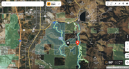
I also was wondering if there was any wqy to connect over to the Inspiration Point Road from Dunn Canyon? Loking on the Onx map of the area, it looks like there is a trail that might connect, but the Marked Dunn's Canyon trail dead ends.
Here's a screen grab on the area from Onx. I'm wondering about what looks like a trail between the black and read pins that I have on the map.
Dunns Canyon.PNG
 

Kevin B.

Not often wrong. Never quite right.
Moderator
Location
Vehicular limbo
MVU maps for Logan and Ogden Ranger Districts would be the official answer. But @Rot Box might know?

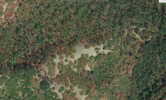
The specific trail you're talking about is probably closed to vehicles and I'm guessing washed out/impassable, because there's a couple spots where it clearly hasn't seen tires in decades. 1696452550775.png
 

moab_cj5

Well-Known Member
Supporting Member
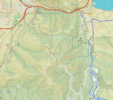
Looking at different layers in GAIA, I only see 1 showing a road there leading me to suspect it is closed. On the FS map, it isn't shown either, further leading me to believe it is closed.

1696452927780.png

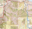
USGS shows a hiking trail instead of a road.
1696452977344.png

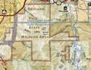
Nat Geo shows nothing.
1696453022436.png

I would reach out to the Logan and Ogden Ranger districts to see what is there. The 023 shows closed to public on the FS Roads layer.
1696453102198.png
 

smfulle

Active Member
Location
Plain City, UT
Thanks for the input guys. Interesting that I have lived here many years and never heard mention (that I remember, which is a big caveat) of a trail that one could drive in Dunn's Canyon.
 

Kevin B.

Not often wrong. Never quite right.
Moderator
Location
Vehicular limbo
Thanks for the input guys. Interesting that I have lived here many years and never heard mention (that I remember, which is a big caveat) of a trail that one could drive in Dunn's Canyon.
It looks pretty well trafficked at least as far what Google Maps calls "Old Pete's Cabin". But I'd check the MVUM or call the local FS office and ask.
 
R

rigastyle047

Guest
Looking at different layers in GAIA, I only see 1 showing a road there leading me to suspect it is closed. On the FS map, it isn't shown either, further leading me to believe it is closed.

View attachment 164776

USGS shows a hiking trail instead of a road.
View attachment 164777

Nat Geo shows nothing.
View attachment 164778

I would reach out to the Logan and Ogden Ranger districts to see what is there. The 023 shows closed to public on the FS Roads layer.
View attachment 164779

Your opinion is interesting. I slightly agree with you here. In general, if I don’t agree with something, then I ask https://studyhelper.com/argumentative-essay-samples to help me. It’s easier for me, because to be honest I’m a little lazy in this regard. I don’t know what to do with this, I can’t bring myself to do it.
wow interesting
 
Last edited by a moderator:

2002maniac

Active Member
Location
Brigham City
I've been up on a dirt bike. No gates or signs indicating closure. The trail is reasonable to the top of the canyon where you overlook into Mantua. From there it turns into a sketchy, steep, ridgeline trail with lots of babyheads, followed by singletrack. I have not gone all the way to Willard basin road, but assume the trail would be fenced and closed from that side.
 
Top