Historical marker help

wick246

Registered User
Location
Magna :0
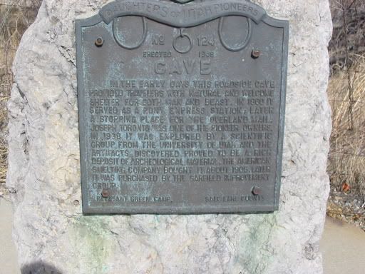
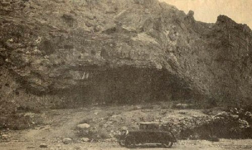
Anyone know about or know where to find more information about the cave located on the north end of the Oquirrh mountains? It is Utah Daughters of Pioneers No. 124 but I cant find any info other than what is on the plaque. From the marker I can't see whether the cave is on the mountain across the road or down the hill behind the marker where you can't see it. Would also like to know what artifacts were found in 1938.

113-1320_IMG.jpg
 

Badger

I am the Brute squad
Location
South Salt Lake
never thought of going there in searching for info.thanks Cruiser.

garfieldpics07.jpg


found this pic.under the picture it was also named "Dead Man's Cave" as well as Toronto Cave

found this little bit of info on a page about Garfields history

in the early history of Utah, Indians used to pass by the area. Some of them would stay at times in a cave at the South West end of the tailings pond. This was called by the locals, Dead Man’s Cave, since a man committed suicide in this cave around 1913. If you are driving West on the freeway just as you pass the pond, look to the North and you will see the cave, also you will see the old highway that used to run just beneath the cave. Skeletons found in the cave show that the Indians lived there somewhere between 3,000 and 7,000 B.C.
 
Last edited:

wick246

Registered User
Location
Magna :0
Thanks guys that's great info. Didn't even know the name of it before. I emailed the Daughters of Pioneers about it in March or April but did not get a response, maybe I will try them again and also have a look at the U of U archeology department for a contact to ask about it.
 
Top