Hole in the Rock

Hideous 4x4

New Member
Location
Nederland CO
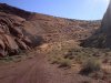
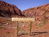
Anybody been on the roads north of Hy. 276 and the Hole in the Rock trail? The Burnt Springs road or any others in that area. Google Earth shows it dropping into Moki Canyon then it follows the wash up it climbs out on the other side, is this a legal trail? Out of the recreation area?
 

cruiseroutfit

Cruizah!
Moderator
Vendor
Location
Sandy, Ut
I was under the impression everything on the north side of the highway was closed with the exception of Red Canyon (further east), however I haven't really looked into it. Check with GCNRA and the BLM down that way and let us know what you come up with, that is a really neat area and I would love to get out on the north side of 276.
 

anderson750

I'm working on it Rose
Location
Price, Utah
I have not looked at the most recent RMP that just came out, so do not take my word as gospel here. Prior to the most recent RMP the roads to the north were open and the road down into Moki canyon (I believe it is called sand slide) was open. There was a sign at the bottom that stated the trail was open due to an agreement between the BLM and San Juan County. I have a picture of it and will post it up after I have a few minutes to look for it.

However, this trail is probably not suited to a full size vehicle. It is steep with some very tight switchbacks. It is maintained by a 48" trailcat, so anything wider than an atv probably would not make it.

I believe San Jaun county has a map of all of this. But remember, there is a new RMP in place, so check with the field office on the status of any of these routes.
 

Hideous 4x4

New Member
Location
Nederland CO
Thanks for the reply's! Do you have any phone #'s of the places to call? Google also showed some roads on the south side of the hwy. We have done Hole in the Rock and the bypass which comes out on the Nokai Dome road, how about the other roads around there?
 

anderson750

I'm working on it Rose
Location
Price, Utah
Here are some pictures of the trail into Moki.
 

Attachments

  • 2003-11- 14&15 Mormon Trail 005.jpg
    2003-11- 14&15 Mormon Trail 005.jpg
    63.8 KB · Views: 27
  • 2003-11- 14&15 Mormon Trail 008.jpg
    2003-11- 14&15 Mormon Trail 008.jpg
    77.5 KB · Views: 50
  • 2003-11- 14&15 Mormon Trail 023.jpg
    2003-11- 14&15 Mormon Trail 023.jpg
    58.8 KB · Views: 31

Hideous 4x4

New Member
Location
Nederland CO
Thanks for the pics!!The road looks wide enough on the bottom but hard to tell coming down the sand slide. I will have a samurai buggy with rear steer, it's 64" wide and 95" wheelbase, that's small but not ATV small. What does GCNRA stand for so I can try to find a phone #, also RNP. Thanks again!
 

anderson750

I'm working on it Rose
Location
Price, Utah
The biggest issue with the trail down the sand slide is that it is maintained by a trail cat which is 48"wide. It is really soft sand, so it could be a big issue of sinking and digging. Aslo, I am not sure if there is a width restriction on this trail.

GCNRA= Glen Canyon National Recreation Area.
RMP= Recreation Management Plan.

The area of the pictures is in Moki Canyon is on BLM land, so if you have any questions, contact the field office in Monticello.

http://www.blm.gov/ut/st/en/fo/monticello.html

For GCNRA, PM Kurt, he knows who to contact there.
 

Hideous 4x4

New Member
Location
Nederland CO
Well it looks like we are heading down there next week, will let you know about the trails. I have heard that the Cal Black airport has auto fuel, I tried to call them but just goes to voice mail, anybody now for sure. We can get fuel at Halls Crossing if not.
Bill
 

cruiseroutfit

Cruizah!
Moderator
Vendor
Location
Sandy, Ut
Well it looks like we are heading down there next week, will let you know about the trails. I have heard that the Cal Black airport has auto fuel, I tried to call them but just goes to voice mail, anybody now for sure. We can get fuel at Halls Crossing if not.
Bill

It was all closed up the last two times I've been through there, we didn't try for fuel but there were no signs of life. We've always gassed up at Halls and called it good.
 

Hideous 4x4

New Member
Location
Nederland CO
It was all closed up the last two times I've been through there, we didn't try for fuel but there were no signs of life. We've always gassed up at Halls and called it good.
We ran HITR last year sept.22nd to 24th, had a plane land as we were heading out, just thought it was open. We will check it out and let you know on the airport. We will try to cover a lot of the trails between Halls and Comb wash. Thanks again for the help!
bill
 

Hideous 4x4

New Member
Location
Nederland CO
We were in the HITR area from the 21st to the 27th, ran about every road in the area that we could find. The Burnt Springs road was open and in great shape, the sand slide was opened up and the ATV,s went down and back with no problem, so I went down in the buggy, I needed to use the rear steer going down on one of the switch backs the front just wanted to wash out even with open diffs. Coming out was no problem except for that one turn, it was very very steep and tight. I made it but it was too close to try it again! Talked to the guy that guides the EJS HITR trip and he said the airport has auto fuel you just have to go in and ask for it.
Bill
 

Hideous 4x4

New Member
Location
Nederland CO
I forgot to mention that the bypass on the HITR trail is the only way in. Lake canyon is closed, you could get a ATV or motorcycle across the wash but nothing wider!
Bill
 
Top