Looking for trail info; Muddy Creek in the San Rafael Swell

Greg

Make RME Rockcrawling Again!
Admin
I'm looking for information on the Muddy Creek in the Swell. I've been looking at the area on Google Earth and it indicates a road that goes thru a pretty deep canyon, called the Muddy Creek Gorge, with a good bit of water running down it. I haven't made it out there, just curious what the road is like.

I'd like to see that area by 4x4 and motorcycle. Anyone been thru there before?
 

cruiseroutfit

Cruizah!
Moderator
Vendor
Location
Sandy, Ut
You know it... :D

Which section are you referring to?

You used to be able to travel along the Muddy Creek from the Hidden Splendor Mine to the Muddy Creek river ford north of Factory Butte. It was closed several years ago, 02'ish. This is the location the disable veteran did the protest ride 2 years ago now? Would be a neat section to drive, could get a bit sketchy with a lot of water. There are some trip reports floating around the web of those that ran it prior to closure, in one case they had to get a tow truck out of Green River to rescue them :D

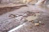
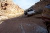
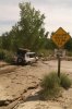
You can still cross the Muddy Creek between Factory Butte and the Little Wild Horse Mesa, it can get nasty and borderline impassible:

You also used to be able to cross the Muddy Creek at the Tomsich Butte Mine, it crossed over and lead on what I believe are some old mine roads on the west side of the river. That was closed several years ago.

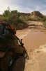
You can also still cross it at the Lone Tree Crossing, nothing major there, its out in the flats and scenic in its own right, worth the drive if you happen to find yourself in the area.

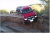
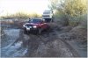
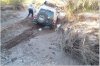
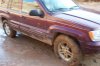
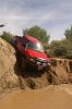
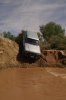
Here is the Muddy Creek crossing north of Factory Butte in the fall of 07', just weeks before the water was running 3-4' deep in spots. We had to drop down the ledges and fight the muddy river bottom through the tamerisk. Richard and I came through there a couple of months ago and it was no problem at all.
 

Attachments

  • SH014 (Medium).jpg
    SH014 (Medium).jpg
    48.4 KB · Views: 34
  • SH015 (Medium).jpg
    SH015 (Medium).jpg
    72.4 KB · Views: 32
  • SH013 (Medium).jpg
    SH013 (Medium).jpg
    78.7 KB · Views: 35
Last edited:

TimB

Homesick
Location
Weatherford, Tx
Lone tree crossing has a bridge - no big deal there.

I crossed between Wild horse and Factory Butte last year near the 2 story cabin - no problem.

I attempted to go from the factory butte crossing to Hidden Splindor - there were no signs of closure from that end but it was really grown up in tamarisk. There were motorcycle tracks but nothing else. It was very sloppy - buried the jeep in a matter of seconds with almost no warning. Take plenty of winches, chains, straps, etc if you try this. I have no plans to try again.

At Tomsich Butte everything on the far side is WSA. It was very muddy and not possible to get near the creek when I was there. The old loop around the butte was also not passible.
 

cruiseroutfit

Cruizah!
Moderator
Vendor
Location
Sandy, Ut
There were signs on the Factory Butte side the last couple of the times I've been through there, and the trail has fences built across at the Hidden Splendor side. :-\

It is a 100% legit historic route, why it was closed I don't know but it happen before I was around the land use scene. :(
 

offroaddave

It's just one term!
Location
sunset
They may now have tow trucks in green river that gan get to where you are, but all they had in 2003 were 2wd. its a long walk to hanksville. I'd read that before but could not resist. :eek:


Lucky for me after walking most of the way back from Hanksville I ran across a man with a plan. And a winch.:)
 

Attachments

  • what not to do 002.jpg
    what not to do 002.jpg
    222.2 KB · Views: 25
  • what not to do 003.jpg
    what not to do 003.jpg
    187.5 KB · Views: 16
  • what not to do 004.jpg
    what not to do 004.jpg
    158.9 KB · Views: 25

TimB

Homesick
Location
Weatherford, Tx
IMO, your time and effort would be better spent trying to get through Salt Creek - the next canyon to the south. I have driven it all but about a 3/4 mile section near the middle. The quicksand turned me back from both ends. If you look on a good map you can see several springs in the area where the quicksand gets bad. They are year-round springs so the quicksand can be bad about any time.:eek:

Photo's and maps available if you decide to give it a shot.;)
 

cruiseroutfit

Cruizah!
Moderator
Vendor
Location
Sandy, Ut
IMO, your time and effort would be better spent trying to get through Salt Creek - the next canyon to the south.

I can't even spot a Salt Creek on the map, there is a Salt Wash that runs perpendicular to Muddy Creek but there are no legal routes in the wash, nor do I think there ever has been? :confused:
 

cruiseroutfit

Cruizah!
Moderator
Vendor
Location
Sandy, Ut
They may now have tow trucks in green river that gan get to where you are, but all they had in 2003 were 2wd. its a long walk to hanksville. I'd read that before but could not resist. :eek:


Lucky for me after walking most of the way back from Hanksville I ran across a man with a plan. And a winch.:)

Sounds like quite the adventure :D

The trip report I read when they had to bring in the 4x4 wrecker was in 2004. Haven't heard much about it in the recent years as its been legally closed since then.
 

Greg

Make RME Rockcrawling Again!
Admin
Great info guys, thanks for weighing in. Sounds like I'll have to check out Salt Creek! Even though Muddy Creek Gorge is now closed to vehicular traffic, I'd still like to see it... sounds like a hike is in order!

Kurt, those pics are incredible! Was it sketchy dropping in with it being so wet? Looks like that was a great trip, is there a report on your site?

Tim, if you have photos handy, I'd love to see what you have of Salt Creek. :)
 

cruiseroutfit

Cruizah!
Moderator
Vendor
Location
Sandy, Ut
...Kurt, those pics are incredible! Was it sketchy dropping in with it being so wet? Looks like that was a great trip, is there a report on your site?...

Yes sir, it was part of the 2007 Outlaws Run where we spent the weekend in the Henry's.

Earlier in the trip we sunk Paul May's 100 Series in the mud in a crossing on the other side of the highway (Town Wash crossing of the Fremont). We had to drop off a nearly 6' vertical ledge there, luckily it was sand and had a solid bottom. Going down was nothing, basically drag the vehicle off the edge and it forms a psuedo ramp. However we got about another 100 yards before the mud stopped us in our tracks. We now had to climb back up the same ledge we had dropped down. Before even attempting we spent the better of an hour building a ramp, once a but of an approach ramp was in place, all of the vehicles were able to rally up it safely. We spent half the day in a 1/4 mile area.

Several days later it was time to cross the Muddy Creek as shown in the pictures. We spent some time devising a route through the muddy wash and getting comfortable with the situation. In both cases the actual river crossing wasn't the sketchy part, rather it was the trail leading to and from the river on both sides. It wasn't as bad as I imagined it would be, we each had to keep the momentum and not slip into the sides of the mud troughs.

Here is the other "drop" (photos courtesy of Perry L :cool:)
 

Attachments

  • PICT0043 (Medium).JPG
    PICT0043 (Medium).JPG
    63.3 KB · Views: 28
  • PICT0025 (Medium).JPG
    PICT0025 (Medium).JPG
    53.5 KB · Views: 29
  • PICT0035 (Medium).JPG
    PICT0035 (Medium).JPG
    43.2 KB · Views: 24
  • PICT0056 (Medium).JPG
    PICT0056 (Medium).JPG
    83.5 KB · Views: 36
Last edited:

TimB

Homesick
Location
Weatherford, Tx
It's definately an old road. There are brown carsonite signs on both ends marking it as open. My mapping computer is not here, but I'll see what I can pull up.

This year we started at the Middle Desert road and went down as far as we could before it got too muddy. And you are correct, it is Salt Wash.

DSCN1709.jpg


DSCN1713.jpg


This was the highlight of the wash - a arch in a volcanic dike.
 
Last edited:

cruiseroutfit

Cruizah!
Moderator
Vendor
Location
Sandy, Ut
It's definately an old road. There are brown carsonite signs on both ends marking it as open. My mapping computer is not here, but I'll see what I can pull up....

Hmmm, I'll have to get down there and check it out, looks neat. The BLM 2006 Motorized Travel Map for the area does not show it as an open route, but it borders the Price District so its possible the other district does?

Edit: There is a road down Salt Wash further down (southwest), it doesn't start at the intersection with Muddy Creek rather it spurs off of the Factory Butte Road a couple of miles before the crossing. I've been down the road a mile or two but didn't drive it enough to hit Salt Wash, I'm assuming this is the "Salt Creek" your referring to?
 

TimB

Homesick
Location
Weatherford, Tx
Yes that is the lower end. The salt wash is a right fork on that end. If you look up salt wash there are springs called Caine Springs - bad quicksand in that area.

Do you know of a good map of Richfield Area designated routes? I'm running off old 7.5 minute maps and a lot of those old roads are gone or closed.
 
Last edited:

cruiseroutfit

Cruizah!
Moderator
Vendor
Location
Sandy, Ut
Yes that is the lower end. The salt wash is a right fork on that end. If you look up salt wash there are springs called Caine Springs - bad quicksand in that area.

That makes sense, so were you able to drive it from the intersection with the Muddy Creek or just from the road and then continued south?

Do you know of a good map of Richfield Area designated routes? I'm running off old 7.5 minute maps and a lot of those old roads are gone or closed.

Nothing out yet that I've seen yet. Richfield and Monticello just had RMP revisions that jostled around a lot of routes. It could be another year before we see Motorized Travel Maps in print. You might find some digital copies on their websites and I know the final RMP/EIS paperwork has site specific maps.

Edit: Here are the RMP maps:
http://www.blm.gov/pgdata/etc/media...ar.62381.File.dat/Richfield Combined Maps.pdf
 
Last edited:

TimB

Homesick
Location
Weatherford, Tx
We drove it from the road to the fork, then up to the springs. We buried 3 out of 4 jeeps in quicksand at that point and decided to give up. At that time it looked like it would tie into Last Chance - but after this last fall's exploration I don't think that is possible.

This year we tried every road off of Middle Desert until we found the one that tied in. There are some excellent dead-end roads along Salt Wash. There were motorcycle tracks on the road fairly recent, and older 4 wheeled vehicle tracks. lots of erosion on the upper end, but once you get into the wash it's very smooth. We got to the muddy part at about dark and turned back. Did not really want to do a winch-fest in the dark.
 

roktaxi

Locked Up = More Freedom
Guy sent me a DVD of your trip... mostly of the Poison Springs Canyon area. It's on my list of WILL do THIS year. He liked it so much he said he'd like to do that trail again. Also looking at the Jacob Chair area the next time he heads this way.
Marty
 

TimB

Homesick
Location
Weatherford, Tx
Hi Marty!

Yeah we had a good trip. I don't think quite as good as in years past but still a lot of country we have not seen before. Guy keeps saying he is headed into Poison Spring to try another road we saw there - I keep telling him to take company but you know how he is. ;):D
 

cruiseroutfit

Cruizah!
Moderator
Vendor
Location
Sandy, Ut
Hi Marty!

Yeah we had a good trip. I don't think quite as good as in years past but still a lot of country we have not seen before. Guy keeps saying he is headed into Poison Spring to try another road we saw there - I keep telling him to take company but you know how he is. ;):D

Is he thinking of the road that heads north around and up onto Bert Mesa to the Dirty Devil Overlook? I know there are some mines along there. Would love to know if its open and accessible.

The Poison Springs Canyon route was for whatever reason left off of the RMP preferred alternative. We (U4WDA) asked all of our members to write letters asking for the inclusion of Poison Springs among others. I honestly haven't had the chance to see if it was included in the final RMP decision but it wold suck to show up there to a closed sign :-\
 

roktaxi

Locked Up = More Freedom
We had planned to go there when he was staying in G.R. but he had to head back to N.M. early. One thing I have to get for the Jeep that I thought I would not ever need : PIA lights! I'm doing a road trip the end of this week in the car to check out some trail heads off of hwy 12 & 95. I want to mark them on my GPS to see if they are on my (updated) TOPO maps I have loaded on my Garmin. I also understand that S.J. county has some good maps of areas off 95. Film at 11.
 
Top