

You are using an out of date browser. It may not display this or other websites correctly.
You should upgrade or use an alternative browser.
You should upgrade or use an alternative browser.
Rumored new trail @ 5 mile ?
- Thread starter Tom95YJ
- Start date
jinxspot
~ Bush Eater's Offroad ~
- Location
- Salt Lake Utah
It was a great run. I think the way we ran it should be the route, then miss that section towards rattlesnake all together and head up and out that other way.
But just my opinion. Still was a great day even tho my rig wasn't there.
It was great to see everyone out with a rig or not... def awesome to see all the cool rigs tackling that area, provided us with some really good feedback!
The original reason it was called sidewinder was because of the twists and turns of the extreme section by the rattlesnake ledges, so I don't see that route changing. Although I must say I was really glad we ran it backwards sunday too, could you imagine taking 15 rigs thru the extreme section to start off with... it would have been an even longer day!!! I ultimately think the exit trail should have a new name, but until one is valid for it we can just call it the exit trail for now. I had an awesome time and it was great meeting everyone!
Attachments
Last edited:
sixstringsteve
Well-Known Member
- Location
- UT
It's good to see so many hardcore crawlers out there.
jinxspot
~ Bush Eater's Offroad ~
- Location
- Salt Lake Utah
That's exactly it, know your land and search the maps!!!It is open......it's public land & it's in an open travel area
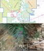
I used the basic tools like "insert/image overlay" option in google earth, then made it fit by a tweak here and there to fit the main landmarks, fire roads and highways... very clearly you can see Sunshine Canyon, very clearly you can see "snakes"... not a whole lot of investigation is needed to give away the spot identified as Five Mile Pass Riding area close to your favorite trails.
snapshot of what this is:
http://www.rme4x4.com/showthread.php?97387-Snakes-on-Cinco-De-Mayo-(05-May-2013)
and the link it came from:
http://www.blm.gov/pgdata/etc/media.../ohv.Par.0009.File.dat/Fivemile_Pass_2007.pdf
From RME post: http://www.rme4x4.com/showthread.php?92433-Is-Snakes-considered-part-of-5MP&highlight=5mile
This map has helped me out a lot lately in order to help distinguish what the open ohv area is at 5 mile pass... take a look and see what ya think in Google Earth. The file called Snakes Trails - 5 Mile Pass.kmz has a transposed BLM map on the trails in google so you know where you’re at for reference.
https://productforums.google.com/forum/#!topic/gec-sports-hobbies/MO2UVQs3w8Y
You can go to the properties of the picture and choose how much transparency you want to show! From rme post: http://www.rme4x4.com/showthread.php?92433-Is-Snakes-considered-part-of-5MP&highlight=5mile
This map has helped me out a lot lately in order to help distinguish what the open ohv area is at 5 mile pass... take a look and see what ya think in Google Earth. The file called Snakes Trails - 5 Mile Pass.kmz has a transposed BLM map on the trails in google so you know where you’re at for reference.
https://productforums.google.com/forum/#!topic/gec-sports-hobbies/MO2UVQs3w8Y
You can go to the properties of the picture and choose how much transparency you want to show!
Attachments
Last edited:
- Location
- Vehicular limbo
With this information, is it possible to start creating more trails out there? It would be great to have a few more in all difficulty levels.
x2. It was something I was kicking around the idea of exploring, but Ryan's map makes it a lot easier. Just need to go find a couple afternoons to drive around the open travel area and figure out what's what.
zuksgonewild
Don't Scuff My Dents!
- Location
- Sandy, Utah
Ran Sidewinder last weekend. Props to who ever built this trail, was a wicked ride. Got caught in the rain, hoping to get to do it again before the season ends.
This trail was created by Ryan! Thank you for doing the research and making this trail for us. I took my little willys jeep on it when he started creating the trail and Ill tell ya he has put a ton of time into it. Its a really fun trail. I cant wait to get my new buggy out there.
eddie d
Member
- Location
- tooele county
there was a guy i didnt know that showed ryan the trail and the map
jinxspot
~ Bush Eater's Offroad ~
- Location
- Salt Lake Utah
hahah ok, don't be jealous man... Everyone knows why the trails in there, but since you don't remember (& that you didn't return to help put any of it in) I'll explain how things came to be... That "guy" you mentioned is my buddy Sean & I stay in contact with him often; he was on the 2013 cinco de mayo run on snakes. He's about ready to get a first hand tour of the trail too, once we find a good time to hit it together.there was a guy i didnt know that showed ryan the trail and the map
Sooo, back April he sent out some messages to me and a few friends on RME because he thought that area above the steep ledges of rattlesnake would be good area for hard obstacles and since it already had old mine roads on it seemed to be a good candidate. No one had even been up there driving yet except when the mining road was in service in the late 70's to 80's (which I found papers from with the prospectors name & company out of NV, that's a whole other story though ).
On the day we all met up out there the group walked it & drove some of the obstacles. After that I took all the GPS coords I gathered and loaded them to google-earth and determined where it was on a map in reference to the Open OHV outline provided by BLM (that's the only maps that I've been showing so far). After that, the president of bush eaters went to go talk with the BLM to make sure all my facts were correct, they substantiated that they were and provided him with some additional information and the requested printouts of the particular area. I then went back out there and walked the whole thing to pick and choose the perfect lines to put in making it the most intense part of the Sidewinder loop... this would end up being the actual obstacles you hit today on the trail that I help create and sean dubbed sidewinder.
Its awesome, there are 3 spots to do front digs, & multiple obstacle's that provide a challenge for even the most built rigs...all while still being tame enough for the above average wheeler to get through safely.
Next the exit portion of the trail came about a month later. I spent just over 2 months out there doing that section of the trail with a few select friends of the Bush Eaters to make sure a complete loop was created before I took select groups actually out on it to get feedback. After a couple runs with 4 & 5 rigs, we implemented a few things different that were part of trial runs and believe we have a pretty good design for a decent trial that will provide lots of fun for the future.
We haves sign's coming soon which we're hoping to put in before it gets too frozen out there, but I can only volunteer so much time before it get's too overwhelming and I miss other trips. I will admit though... everyone I've taken out there so far loves it (thats about 50 waaay cool rigs)!!! Sometimes it takes 3 hours... sometimes it can take over 5 hours just depends on how fast ya wanna go, how man people you have and what type of rig you drive. I've personally spent over 7 hrs on it with groups above 10.
So without further delay or "peoples" misunderstandings about the trail here's the link to it.
http://www.rme4x4.com/showthread.php?99713-Fairfield-UT-Sidewinder-Trail-Loop
Last edited:
- Location
- Grand Junction, CO
Good to hear there are more hardcore, legal trail options at 5MP!
Just curious, is this anywhere near the 'Copperhead' trail? It was a trail that wasn't legal, but some people were poaching it and running it anyway. It's too bad, because it also had potential.
Just curious, is this anywhere near the 'Copperhead' trail? It was a trail that wasn't legal, but some people were poaching it and running it anyway. It's too bad, because it also had potential.
brandonlmb
brandonlmb
- Location
- Farmington
Good job!
jinxspot
~ Bush Eater's Offroad ~
- Location
- Salt Lake Utah
Good to hear there are more hardcore, legal trail options at 5MP!
Just curious, is this anywhere near the 'Copperhead' trail? It was a trail that wasn't legal, but some people were poaching it and running it anyway. It's too bad, because it also had potential.[/URL]
im not aware of where the copperhead trail is because its illegal for 4x4's... and haven't got off my but to hike in. There's been talk of a couple other trails up there around my campfire circles, but they are for hiking pleasure only so I focus all my time in the BLM designated areas and haven't gotten bored yet.... Although I'm still new the state.
jinxspot
~ Bush Eater's Offroad ~
- Location
- Salt Lake Utah
. Thanks man, well get ya up there for the party soon enough!!!Good job!
chadschoon
Well-Known Member
- Location
- lehi
It is a great trail. Thanks for putting all the time and effort into it. It puts the snakes and constrictor to shame.
Good to hear there are more hardcore, legal trail options at 5MP!
Just curious, is this anywhere near the 'Copperhead' trail? It was a trail that wasn't legal, but some people were poaching it and running it anyway. It's too bad, because it also had potential.
Is this the trail that was referred to as "Charlie's Trail?"
- Location
- Grand Junction, CO
im not aware of where the copperhead trail is because its illegal for 4x4's... and haven't got off my but to hike in. There's been talk of a couple other trails up there around my campfire circles, but they are for hiking pleasure only so I focus all my time in the BLM designated areas and haven't gotten bored yet.... Although I'm still new the state.
:thumbs:
Honestly, I don't know where it is either... but I heard where it was and it's not far from RS. Before I left Utah, I spent a LOT of time out there scoping out trails and hiking various canyons, often with other RME members. There seems to be enough private land to screw up most potential trails, etc, etc.
Thanks for all the footwork on making sure this was a legal trail and that the BLM was good with it, some guys don't get that aspect of wheelin.
Is this the trail that was referred to as "Charlie's Trail?"
Nope, Charlies Trial is on the South side... I've hiked it, but the pics don't look similar at all. The BLM didn't want that being driven on, due to being a watershed location/canyon.
wydej
LJSean
- Location
- Sandy, Utah
It is nice to see people having fun on sidewinder. I am not sure if it could be Charlie's trail because with the exception of the first obsticale on the trail it had never been driven before. I actually walked and mapped out the trail in november of 2012. There were a couple of cairnes at the begining of the trail but definatley never driven and the cairns did not continue. The Bush Eaters and I did the first trail run in April 2013. Unfortunatley after that I only made it back for one more run then my jeep broke (not on sidewinder) and will be out of commision until next year but I hear the Bush Eaters have fixed it up and established it very well. As far as the location it is hard to miss the start half way through Rattle Snake you turn left and wind up the side of the mountain that is why I called it side winder(refer to the maps posted previously). After the first obsticale it can be trickey to navagate so it would be best to ride with some one who knows the trail first. If anyone does not like the name side winder I jokingly named the trail one eyed snake at first but decided not everyone would appriciate the humor in that name. Every one have fun and I will be running it with you all again in the spring.
Last edited:
jmaxj
This sucks!!!!
- Location
- were ever i feel i need to be.....
Its not Charlies trail, wrong side of highway