Record Snow pack, floods next?

shortstraw8

Well-Known Member
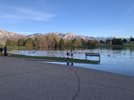
I can't see them in the aerials posted, but does kinda look like flat pathway bricks from that pick.
slackaerials.jpg

That was posted coworker, but is not my coworker just someone from that hood.
 

nnnnnate

Well-Known Member
Supporting Member
Location
WVC, UT
Does anyone know about water drainage from the Oquirrh mountains? Growing up on the west side I never saw running water and while there are a few drainages I know about (one of them running through my parents neighborhood in WJ) I've never seen water flow. What happens to the snow there? Are there creeks or streams or anything like that which drain into anything? Does it just soak into the soil?

I've been thinking about it the last few days while driving home on U111 from picking up my youngest.
 

johngottfredson

Threat Level Midnight
Location
Alpine
I’d definitely be looking into how those retaining walls were constructed. Water saturated soil will blow those out pretty easy, even with a concrete footing.
There’s no retaining wall on the market that would stop a land-sliding house. It’s 100% filling in a ravine with dirt and putting houses on top that’s the issue. They used “engineered fill”, but it’s very clearly not the same as native stabilized soil.
 

N-Smooth

Smooth Gang Founding Member
Location
UT
There’s a neat letter from Edge floating around on social from last fall that states that they disagree with the city’s decision to condemn the houses and that they will install columns to help stabilize the soil etc.
 

STAG

On my grind
Location
Pleasant Grove
As a self-proclaimed dirt specialist, from those pictures I would absolutely say that dirt was not built up correctly at all and that is solely the reason for the collapse. If it had been properly compacted in lifts I think we’d not be seeing that house have issues.

Every day houses are built on imported and compacted fill, even in ravines. It’s the method and practice of the install that is what’s important and they obviously skimped.
 

jeeper

Currently without Jeep
Location
So Jo, Ut
Those retaining walls were massive. We would ride bikes on the trails right behind the houses, and every time comment on how big they were. I literally think they were like 40 feet tall, and they had multiples of them. I was surprised they were holding back the dry dirt. I thought they would have bowed out easily.
 

jeeper

Currently without Jeep
Location
So Jo, Ut
Does anyone know about water drainage from the Oquirrh mountains? Growing up on the west side I never saw running water and while there are a few drainages I know about (one of them running through my parents neighborhood in WJ) I've never seen water flow. What happens to the snow there? Are there creeks or streams or anything like that which drain into anything? Does it just soak into the soil?

I've been thinking about it the last few days while driving home on U111 from picking up my youngest.

The majority of the water is underground. It pops back up in a couple different places, but eventually ends up in the Jordan river for the most part. My neighborhood has four underground and above ground rivers that are directly fed from those mountains. A handful of years ago the city put in massive water pumps along 13th west to help control the underground water.

At least, that is my experience and knowledge, especially for the South end of the mountains
 
Last edited:

nnnnnate

Well-Known Member
Supporting Member
Location
WVC, UT
I wonder if the water was pushed underground to control it better or if was always like that. Now that you say that I remember hearing there was some infrastructure added around bangerter and 5400 south not too long ago to deal with underground water. Interesting placing though because it dips down a fair amount just east on the road.

I did try and do a little googling but didn't find anything.

The one thing that I'm not happy about is the extra bad mosquito season we'll have. They are already out by me.
 

RockChucker

Well-Known Member
Location
Highland

I Lean

Mbryson's hairdresser
Vendor
Location
Utah
I'm sure the data is out there, but I'd like to know how much water this 50 ft will contain, versus the NEXT 50 feet. (but I don't want to know badly enough to actually look) Since the reservoir gets wider as it gets more full, this "first" 50 feet won't take as much water as the "next", and the "next" after that.
 

Jesser04

Well-Known Member
Location
Kaysville Utah
Sugarhouse park is taking on water we were here yesterday and it looked nothing like this.
 

Attachments

  • 8F7E0723-E86B-4C11-AADA-1CA7B6A5C8F9.jpeg
    8F7E0723-E86B-4C11-AADA-1CA7B6A5C8F9.jpeg
    400.3 KB · Views: 54
  • F0D74C94-82CC-4D17-8866-20A92FEAB9CE.jpeg
    F0D74C94-82CC-4D17-8866-20A92FEAB9CE.jpeg
    424.6 KB · Views: 54
  • 5AE12189-FA72-4EDA-961D-2D4F690D244D.jpeg
    5AE12189-FA72-4EDA-961D-2D4F690D244D.jpeg
    416 KB · Views: 52
  • 2F54786F-D089-4281-BBB6-E2D2E22D5721.jpeg
    2F54786F-D089-4281-BBB6-E2D2E22D5721.jpeg
    609.4 KB · Views: 52
  • AC0DCF67-FEDF-49A5-A140-333CC7A20396.jpeg
    AC0DCF67-FEDF-49A5-A140-333CC7A20396.jpeg
    666 KB · Views: 54

UNSTUCK

But stuck more often.
I'm sure the data is out there, but I'd like to know how much water this 50 ft will contain, versus the NEXT 50 feet. (but I don't want to know badly enough to actually look) Since the reservoir gets wider as it gets more full, this "first" 50 feet won't take as much water as the "next", and the "next" after that.
My guess is not that much more. Some places like lone rock are definitely wider, but there is so much cliff face that the water can only go straight up.

Remember that cliff jump we played on? I wonder how high that jump would be now?
 
Top