Tacoma
Et incurventur ante non
- Location
- far enough away
I thought that was BC, just wanted to make sure. 
I think he was friends w/Travolta's dad or something, wasn't he?
I think he was friends w/Travolta's dad or something, wasn't he?
Wow. I thought I was grateful to all you guys before, just for giving me hope that I would be able to put this behind me at some point, but I really am at a loss for words as to how much this means to me. I hope that every time you pull someone out of trouble, whether their own bad judgment or weather, or the fault of another, they are as grateful as I am right now. I keep trying to think of something I can do to maybe make it up to all of you, but it seems like the only thing I can do is to make sure that whenever I see someone in distress on the road, or in some kind of need, to do what I can, however small, to help them out of that trouble. I seriously doubt any one of your will ever need help out of a jam like this one, but I sure hope all of you will save my number, and if you ever need help, please let me give it a shot. One thing I have plenty of is time, and I can't think of anything I'd rather do with it than help or just hang out with you fellows talking Jeeps. I realize that the Libby is woefully inadequate for most of the trails you run, but until I can either get a more suitable rig, or get the Libby up to snuff, I would be delighted to ridealong on some trails and become better acquainted with all of you.
As far as the Liberty is concerned, it seems to be tracking nicely. I didn't notice any pull or malignment on the drive home. I did overheat, as most of you are aware, on the last stretch back to the pavement, but it took two gallons of coolant, and I think I will need to check and see how that got out of there. Hopefully nothing too serious, but you never can tell. It got out of there somehow. Medsker was good enough to follow me most of the way home to make sure everything was ok, (thanks, yet again) and I was able to get the plastic fender re-attached with some wire, which should hold it until the new one comes in. I will have it in the body shop later this week to see what it wil take to fix that fender, and little bit of hood, but I will take a photo of it today and post how it's looking now with the fender back on (sort of).
Once again, THANK YOU THANK YOU THANK YOU for the time off work (I heard a lot of complaining about that) the cookies and water (Timp) the expertise, the support, the hope, and just for being a great group of terrific folks. I can't remember when I have enjoyed meeting any group more, under any circumstances.
Best regards, and I hope to see all of you again soon.
Dave Wallentine
Just to clarify it wasn't Medsker that followed you home
I keep trying to think of something I can do to maybe make it up to all of you...
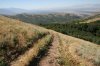
...Hey Marc, did you get any shots of the valley? The view from up there ROCKED!
Very bonehead, but you already know that. Rolling happens, passing legit signs of closure or restricted use shouldn't.
... And had their not been a fire the gates would have been shut?
one would assume the route they were on was open. I'm assuming the signs we saw were left overs of a time the route was open?
That second gate, just a short distance up from the first gate was shut and locked this morning.
This morning yes, but when the fire was going and Dave drove up, they were all wide open.
Kinda makes you wonder why they closed it.
If you missed the signs at the second gate...
The road we were on continues either down into Bountiful or another 5 miles east to Rudy's Flat and mabey as far as the Burro Mine.
understood ... I was trying to re-enforce what you were saying about Dave and the ambiguous nature of the situation.
...Legit and open or erroneously closed historic route?
Lack of want to manage
Neighbors not wanting high volumes of traffic in the area
You do cross SLC's watershed, they are adamant about keeping vehicles out of their watershed regardless of historic access (think Cardiff Fork)
Possibly security concerns with the amount of radio towers and repeaters in the area.
User conflicts, the area is popular with hikers and I'd assume Mtn Bikers, there was even a dog poop bag station 1/2 way to the Liberty??
The latter...
Early USGS maps all the way up to the mid-80's show routes all over the area, an old gun range, etc. Its a Big Cottonwood Canyon situation, or a Pittsburg Lake, or a Corner Canyon or a etc.... situation. Administratively closed routes that were in place for 50 or more years. While many of the routes are likely less than 30 years old, the Bonneville Trail (Jeep Road) that he started on was a major route in the 70's. Its now part of the Bonneville Shoreline Trail, closed to motorized access.
Ah, check. You're always so informative. How may I subscribe to your newsletter?